 Map Shows that Hottest Day of the Year Is Still To Come in Many States
Love the Heat or Hate it, This Map Will Show You What Day Should Be Hottest In Each State
This Map Shows When Each State Can Expect Its Hottest Day of the Year
Map Shows When Each State Can Expect Hottest Temperatures
Map Shows that Hottest Day of the Year Is Still To Come in Many States
Has Been Optimized
Though many people have felt themselves thoroughly beat by the heat in the past few days, for most of the United States, the hottest part of the summer is still to come.
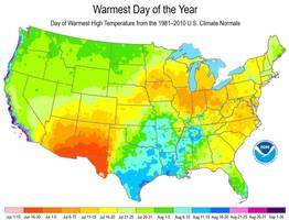
The National Climate Data Center has compiled data on the warmest days of the year since the early 1980s.
Using this data, the center has created a map indicating an approximate date range of when each part of the US can expect to encounter its hottest temperatures.
Some states, such as Arizona, New Mexico and parts of Texas, might have already passed their temperature peak.
Others, however, are still heading towards theirs.
According to the map, the northwest section of the country can expect the hottest temperatures in late July to early August; east coast states such as New Jersey, Pennsylvania and most of New York, by contrast, can expect temperatures to peak between July 11 and July 20.
The areas directly on the Pacific coast can expect their hottest days to come later still: due to their location on the ocean, their warmest days aren’t anticipated until late August or early September.
The data center explained that the temperature increase later in the summer – despite the increasingly shorter days – can be attributed to the fact that the rate of heat coming in from the sun during the day exceeds the rate of cooling that takes place at night.
The National Climate Data Center has noted that “while the map shows warmest days of the year on average throughout the United States, this year’s actual conditions may vary based on weather and climate patterns.”
Sources: The Blaze, Scientific American
Photo Sources: The Blaze, The Times
Video Piece:
Regular Piece Reported by Opposing Views 1 hour ago.